Development of comparison support tools for historical maps using IIIF

1. Introduction

The Historiographical Institute at the University of Tokyo has made available online IIIF images of two significant maps. The first is the 'Shōhō Ryūkyū Kokuzū,' owned by the institute. The second is the 'Ryūkyū and Various Islands Map,' which belongs to the Miyakonojō Shimazu Residence in Miyazaki Prefecture, Japan. The former, a map series of each country started in 1644 by the Edo shogunate, includes 895 annotations related to place names in the Ryukyu Kingdom of Japan. The latter, a large folding map created between 1635 and 1666, depicts the southwestern islands of Japan and contains 754 annotations.

This research aims to develop tools to support comparative analysis of historical maps using IIIF. This includes the integration and comparison of historical maps with modern maps. Based on case studies of comparing multiple maps mentioned above, the usefulness of the tool will be verified.

2. Approach

2.1. System requirements

To support the aforementioned research, the following platform is envisioned:

In realizing these functions, useful technologies such as georeferencing and side-by-side image display using Mirador IIIF Viewer have been proposed, but the following challenges were identified:

2.2. Existing Research

There are numerous studies that support the viewing and analysis of maps and historical maps. Furthermore, many tools, such as Old Maps Online, Map Warper and Map Folder (El Khatib 2020), are also available. This study focuses on analyzing maps that are annotated with place names and comply with IIIF. Recently, methods combining IIIF with georeferencing have emerged, and tools and viewers utilizing IIIF for georeferencing, such as Georeferencer (Kowal et al. 2012) and Allmaps (Allmaps 2024), have been developed. In May 2023, the IIIF Georeference Extension (Georeference Extension 2024) was also released. This research distinguishes itself by developing analysis support tools, utilizing the existing research outcomes and considering the recent trend of employing IIIF in map and diagram analysis. 

3. Developed Tool

3.1. Side-by-Side Display of Modern Maps and Historical Maps

Figure 1 shows a screen example of the viewer developed for this annotation data, which is created with Allmaps. It provides a modern map, diagram, a list of place names, and a search function. By clicking on a marker on the modern map or an annotation on the diagram, the corresponding location on the other is focused. This functionality and viewer allow the user to check the correspondence between the diagram and the modern map without distorting the diagram.

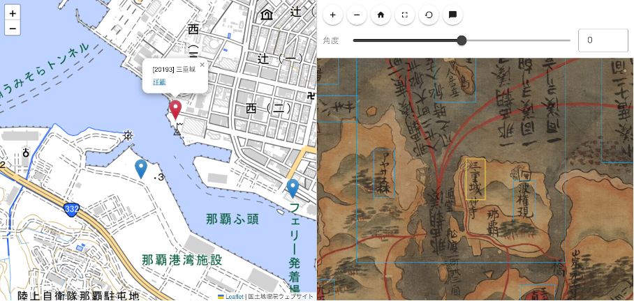
Figure 1: Side-by-Side Display of Modern Map and Historical Map

3.2. Support for Comparing Multiple Historical Maps

It is assumed that the place names within each map image being compared are annotated. Furthermore, each place name is assigned an ID, and it is assumed that the relationships between corresponding place names in different maps can be retrieved through IDs or similar means. For such data, the annotation description defined in the IIIF Presentation API has been partially extended. A field named 'cid' (common ID) was added to propose a description method that assigns a common ID to corresponding place names. Additionally, a viewer has been developed that can load manifest files with this description, search for annotations with corresponding IDs in multiple historical maps, and focus on the corresponding annotations.

Figure 2 illustrates an example where a list of place names is displayed at the center of the screen, with corresponding place names in the left and right historical maps being automatically focused.

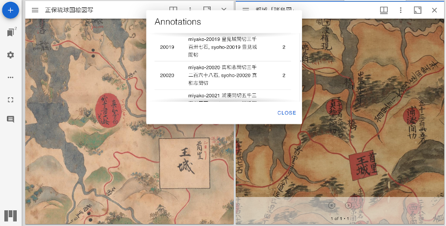
Figure 2: Mirador Plugin for Comparing Multiple Historical Maps

4. Conclusion

This paper has presented the development of tools designed to support the comparative analysis of historical maps. A detailed case study utilizing this tool will be described, adding content to evaluate its usefulness based on feedback from historical researchers.

Appendix A

Bibliography
  1. El Khatib, R. and Schaeben, M. (2020). Why Map Literature? Geospatial Prototyping for Literary Studies and Digital Humanities. Digital Studies/Le Champ Numérique, 10(1): 7 doi:10.16995/dscn.381.
  2. Kowal, K. C. and P[rbreve]idal, P. (2012). Online Georeferencing for Libraries: The British Library Implementation of Georeferencer for Spatial Metadata Enhancement and Public Engagement. Journal of Map & Geography Libraries, 8(3): 276–89 doi:10.1080/15420353.2012.700914.
  3. Otsuka, K. (2019). Historical map viewer technology that guarantees nonlinear bijective conversion without distortion. Abstracts of the ICA, 1: 1–2 doi:10.5194/ica-abs-1-284-2019.
  4. Allmaps Allmaps https://allmaps.org/ (accessed 15 June 2024b).
  5. Georeference Extension https://iiif.io/api/extension/georef/ (accessed 15 June 2024c).
Satoru Nakamura (nakamura@hi.u-tokyo.ac.jp), The University of Tokyo, Japan and Satoru Kuroshima (kurosima@hi.u-tokyo.ac.jp), The University of Tokyo, Japan and Shuhei Hatayama (hatayama@hi.u-tokyo.ac.jp), The University of Tokyo, Japan and Taizo Yamada (t_yamada@hi.u-tokyo.ac.jp), The University of Tokyo, Japan